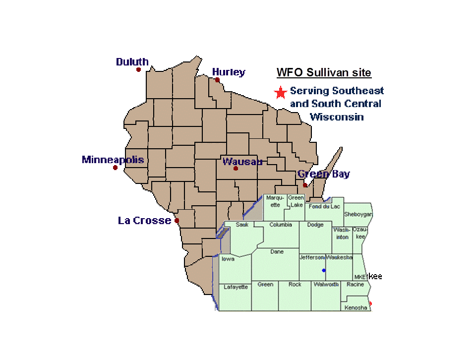
The National Weather Service (NWS) Milwaukee/Sullivan, WI accepts storm reports from the highlighted counties on this map. A quality report includes Who, What, When, and Where information.
WHO….Trained spotter, ham radio, Law enforcement, etc.
WHAT…. Estimated winds 55-60 MPH, 1 inch hail, etc.
WHEN…. 7:23PM
WHERE….(any) Your Address/city/county
Nearest cross streets/city/county
Distance & direction to nearest city in your county + county.
Lat & Long data (GPS) in decimal format + one of the above.
**For precise locations see the Cultural/City Centers data below to determine your exact location from a NWS mapped landmark. Do this for home and office.
Criteria
TORNADO – INCLUDE COMAPSS DIRECTION YOU ARE LOOKING.
WATERSPOUT – INCLUDE COMPASS DIRECTION YOU ARE LOOKING.
FUNNEL CLOUD – INCLUDE COMPASS DIRECTION YOU ARE LOOKING.
ROTATING WALL CLOUD – INCLUDE COMPASS DIRECTION YOU ARE LOOKING.
HAILSTONES – REPORT THE LARGEST SIZE, SPECIFY IF MEASUREMENT OR ESTIMATE.
WINDS GUSTS 40+ MPH – SPECIFY IF MEASUREMENT OR ESTIMATE.
DAMAGE: TREES, POWER POLES, BUILDINGS, WINDOWS, WALLS, ROOFING, BASEMENT CAVE-INS, LIGHTNING RELATED DAMAGE, FIRE, INJURY.
FLOODING: Water over the curb, covering the street. Rushing water or stationary? More than 2 feet deep? In basement or commercial buildings.
FREEZING RAIN to the nearest 1/10″ e.g. 0.1″
ICE GLAZING to the nearest 1/10″ e.g. 0.1″
SLEET resembles hailstones, bounces off the ground.
RAINFALL – RAIN GAGE: INCLUDE MEASUREMENT PERIOD (“1.30 Inches between 12AM to 6AM”)
SNOW FALL to the nearest 1/10 inch. e.g. 1.2″
Avoid measuring near buildings, measure different locations obtain average. Watch out for blow and drifting. Measure every 6 hours. SNOW DEPTH: Total on ground or NEW SNOW: Latest snowfall this event.
VISIBILITY LESS THAN 1/4 MILE: FROM SNOW, FOG, RAIN, OR DIRT.
WHITE OUT CONDITIONS: Daytime event.
Submit Report
SOCIAL MEDIA (Require membership of Twitter or Facebook):
http://twitter.com/NWSMKX
http://www.facebook.com/US.NationalWeatherService.Milwaukee.gov
CALL THE NWS 800 NUMBER
For Tornadoes and Funnel clouds only
“Hello, I am a trained severe weather spotter,
at 7:17PM I observed funnel/tornado. My location
is 2 miles west of the Waukesha airport, Waukesha Co.
I lam looking north. My name, call, badge # etc is____.
AMATEUR RADIO: FREQUENCY 146.910 (when Active)
SHARE YOUR REPORTS WITH US:
After making a official report to the NWS, share your report or photo via our Facebook Group. Report
All reports should be your first-hand observations. If you did not see it, don’t report it. Never use hearsay or second-hand information from texts, social networks, radio-TV, police scanners, or friends, etc.
Submitting false storm reports is a violation of the False Statements Accountability Act of 1996. (18 USC 1001)
Fines range up to $250,000 and/or up 5 years in prison.
Cultural/Political City Centers
Within your county determine your distance and direction to the center of your city (or nearest city/landmark). County maps are listed below.
| Columbia | Dane | Dodge | Fond Du Lac | Green | Green Lake | Iowa | Jefferson | Kenosha | Lafayette |
| Marquette | Milwaukee | Ozaukee | Racine | Rock | Sauk | Sheboygan | Washington | Walworth | Waukesha |
| Columbia County | |||
| City | City Center or Landmark | GPS City Center | |
| Arlington | Intersection of Santa Maria Dr & Buena Vista Dr. | 43.3385 | 89.3766 |
| Cambria | Intersection of Center St. & Roberts St. | 43.5409 | 89.1138 |
| Columbus | Intersection of STH 73 & STH 16/60 | 43.3381 | 89.015 |
| Doylestown | Intersection of CTY A & Columbus St. | 43.4276 | 89.1462 |
| Fall River | Intersection of Bradley St. & Kane St. | 43.3851 | 89.0477 |
| Friesland | Intersection of CTY EF & Winnebago St. | 43.5890 | 89.0678 |
| Harmony Grove | Intersection of CTY V & Harmony Dr. | 43.3724 | 89.5394 |
| I-90/94/39 | At Wisconsin River Bridge (over Wisconsin River) | 43.4480 | 89.494 |
| Keyeser | Intersection of CTY DM & CTY C | 43.2965 | 89.2555 |
| Lodi | Intersection of Chestnut St. & Prairie Ave. | 43.3164 | 89.5321 |
| North Leeds | Intersection of STH 60 & 22 | 43.3322 | 89.3256 |
| Okee | Intersection of STH 113 & CTY V | 43.3563 | 89.5828 |
| Otsego | Intersection of Otsego Rd. & Columbus Rd. | 43.4023 | 89.1653 |
| Pardeeville | Intersection of STH 22 & CTY P | 43.5341 | 89.3003 |
| Portage | Intersection of HWY 51 & Railroad Tracks | 43.5392 | 89.4616 |
| Poynette | Intersection of W. Seward St. & Meadow Ln. | 43.3908 | 89.4082 |
| Wisconsin Della | Intersection of HWY 16 & River Rd. | 43.6274 | 89.7753 |
| Wyocena | Intersection of STH 22 & Railroad Tracks | 43.4931 | 89.31 |
| Dane County | |||
| City | City Center or Landmark | GPS City Center | |
| Albion | Intersection of STH 106 & Albion Rd. & Edgerton Rd. | 42.8803 | 89.0688 |
| Belleville | Intersection of Harrison St. & STH 69/92 | 42.8617 | 89.5365 |
| Black Earth | Intersection of Park St & East St. | 43.1366 | 89.7461 |
| Blue Mounds | Intersection of Main St. & Division St. | 43.0171 | 89.832 |
| Cambridge | Intersection of STH 12 & CTH B (Spring) | 43.0035 | 89.0165 |
| Camp Randall Stadium | Intersection of Regent St. & N Breese Terrace | 43.0687 | 89.4129 |
| Cottage Grove | Intersection of CTY N & Clark St. | 43.1993 | 89.0764 |
| Cross Plains | Intersection of Grand St & Jovina St. | 43.1139 | 89.6462 |
| Daleyville | Intersection of STH 78 & Grinder Rd. | 42.9148 | 89.9148 |
| Dane | Intersection of STH 113 & Military Rd | 43.2458 | 89.3458 |
| Deansville | Intersection of CTY TT & Ridge Rd. | 43.1812 | 89.1038 |
| Deerfield | Intersection of STH 73 & Liberty St. | 43.0514 | 89.0743 |
| DeForest | Intersection of CTY CV& Acker Pkwy | 43.2497 | 89.344 |
| East Bristol | Intersection of CTY VV & CTY V | 43.2681 | 89.1515 |
| Fitchburg | Intersection of CTH D & CTH PD (McKee) | 43.0155 | 89.4243 |
| Henry Vilas Park Zoo | Intersection of S Randall Ave & Vilas Park Dr. | 43.0587 | 89.41 |
| I-90/94/39 Interchange | Southbound overpass of I90/39 where it meets I-94/STH30 | 43.1041 | 89.2856 |
| London | Intersection of STH 134/CTY O & Main St. | 43.0469 | 89.0113 |
| Downtown Madison | Center of Capitol Square | 43.0747 | 89.3842 |
| Madison Truax Airport | Terminal Bldg near end of International Lane | 43.1403 | 89.3319 |
| Marshall | Intersection of STH 19 & CTH T | 43.1682 | 89.0661 |
| Marxville | East Intersection of STH 19 & CTY KP | 43.1909 | 89.6599 |
| Mazomanie | Intersection of Brodhead & W Exchange St. | 43.1744 | 89.7948 |
| McFarland | Intersection of Bashford St. & Exchange St. | 43.0128 | 89.2898 |
| Middleton | Intersection of CTY MS & Parklawn Pl. | 43.0920 | 89.5041 |
| Monona | Intersection of Midmoor Rd. & Nichols Rd. | 43.0622 | 89.3334 |
| Morrisonville | Intersection of CTY DM & Lynn St. | 43.2775 | 89.3596 |
| Mt. Horeb | Intersection of STH 78 & 2nd St. | 43.0084 | 89.7384 |
| Mt. Vernon | South Intersection of STH 92 & CTY G (Davis St.) | 42.9468 | 89.6563 |
| Oregon | Intersection of Main St. & STH 138/CTH CC | 42.9263 | 89.3821 |
| Paoli | Intersection of Range Trail & CTY PB (Paoli Rd) | 42.9294 | 89.5263 |
| Roxbury | Intersection of CTY Y & Kippley Rd | 43.2494 | 89.6751 |
| Shorewood Hills | Intersection of Western Rd & Tallyho Ln. | 43.0777 | 89.4465 |
| Springfield Corners | Intersection of HWY 12 & CTY P | 43.1916 | 89.5661 |
| Stoughton | Intersection of STH 51 & S. 4th St. | 42.9168 | 89.2178 |
| Sun Prairie | Intersection of W. Main St./S. Bristol/STH19 | 43.1834 | 89.2138 |
| Token Creek | Intersection of STH 19 & Portage Rd. | 43.1945 | 89.2934 |
| Utica | Intersection of CTY B & CTY W | 42.9658 | 89.1218 |
| Verona | Intersection of W. Park Ave & S Schuman St. | 42.9888 | 89.5354 |
| Waunakee | Intersection of STH 19 & South St. | 43.1917 | 89.4552 |
| Windsor | Intersection of CTY CV & Windsor Rd | 43.2167 | 89.3421 |
| Dodge County | |||
| City | City Center or Landmark | GPS City Center | |
| Ashippun | Intersection of STH 67 & CTY O | 43.2118 | 88.5163 |
| Astico | Intersection of CTY T & Alto Dr. | 43.3325 | 88.9404 |
| Atwater | Intersection of CTY C & railroad tracks | 43.5607 | 88.7346 |
| Beaver Dam | Western Inters. of STH 33 & STH 151 (S. Center Rd.) | 43.4563 | 88.8396 |
| Brownsville | Intersection of STH 49 & Clark St. | 43.6157 | 88.4913 |
| Burnett | Intersection of STH 26 & Main St. | 43.5047 | 88.7084 |
| Clyman | Intersection of Main St. & CTY J | 43.3121 | 88.7193 |
| Danville | Intersection of CTY T & CTY TT | 43.3197 | 88.9563 |
| Fox Lake | Intersection of STH 33 & STH 68 | 43.5662 | 88.9067 |
| Horicon | Eastern Intersection of STH 33 & CTY E (N. Hubbard St.) | 43.4516 | 88.6299 |
| Hustisford | Intersection of CTY E & Highland St. | 43.3455 | 88.6036 |
| Iron Ridge | Intersection of Main St. and E. Pleasant St. | 43.3976 | 88.5321 |
| Juneau Dodge Airport | intersection of STH 26 & Saint Ann Rd. | 43.4274 | 88.6994 |
| Juneau | Intersection of STH 26 & STH 115 | 43.4063 | 88.7033 |
| Knowles | Intersection of CTY Y & CTY AY | 43.5731 | 88.5001 |
| Le Roy | Intersection of CTY Y & CTY YY | 43.5735 | 88.561 |
| Lebanon | Intersection of STH 109 (R) & CTY MM | 43.2554 | 88.6267 |
| Leipsig | Intersection of CTY G & CTY S | 43.4007 | 88.8638 |
| Lomira | Intersection of Sterr Park & Pleasant Hill St. | 43.5889 | 88.4447 |
| Lowell | Intersection of CTY G/GI & Dodge St. | 43.3378 | 88.8209 |
| Mayville | Intersection of STH 28 & CTY Y | 43.4982 | 88.5462 |
| Minnesota Jct. | Intersection of Center St. & North St. | 43.4523 | 88.6961 |
| Neosho | Intersection of STH 67 & CTY NN | 43.3097 | 88.5178 |
| Randolph | Intersection of Stark St. & Columbus St. | 43.5378 | 89.0022 |
| Reeseville | Intersection of CTY G/GI & Suncrest Dr. | 43.3059 | 88.8451 |
| Richwood | Intersection of CTY Q & Link St. | 43.2412 | 88.7847 |
| Rubicon | Southern Intersection of CTY N & CTY P | 43.3399 | 88.4584 |
| South Beaver Dam | Intersection of CTY DE & CTY D | 43.4408 | 88.8898 |
| Theresa | Intersection of STH 175 & Henni St. | 43.5178 | 88.4527 |
| Watertown (Dodge Co) | Intersection of S. 1st St. & Dodge St. | 43.1916 | 88.7249 |
| Waupun | Intersection of STH 49 & Drummound St. | 43.6333 | 88.7335 |
| Woodland | Intersection of N. CTY WS & Woodlawn Rd. | 43.3705 | 88.5194 |
| Fond Du Lac County | |||
| City | City Center or Landmark | GPS City Center | |
| Ashford | Intersection of STH 67 & Drumlin Dr. | 43.5870 | 88.3658 |
| Brandon | Intersection of Jefferson St. & N. Center St. | 43.7374 | 88.7838 |
| Byron | Intersection of STH 175 & W. Byron Rd. | 43.6497 | 88.4512 |
| Campbellsport | Intersection of STH 67 & Poplar St. | 43.5994 | 88.2813 |
| Dundee | Southern Intersection of STH 67 & CTY F | 43.6492 | 88.1784 |
| Eden | Western Ints. of HWY 45 & CTY B (S. Fond du Lac Ave.) | 43.6924 | 88.3628 |
| Eldorado | Intersection of CTY C and Town Hall Rd. | 43.8260 | 88.6216 |
| Fairwater | Intersection of Cass St. & Church St. | 43.7411 | 88.8688 |
| Fond Du Lac | Intersection of Main & Division St. | 43.7783 | 88.4468 |
| Fond du Lac Airport | West Grove St./Terminal Bldg | 43.7714 | 88.4866 |
| Ladoga | Intersection of STH 26 & CTY TC | 43.7203 | 88.6755 |
| Lamartine | Intersection of CTY Y & Lincoln Rd. | 43.7334 | 88.5704 |
| Marytown | Intersection of STH 149 & Roehrig Rd. | 43.9127 | 88.2026 |
| Mt. Calvery | Intersection of Dix Rd. & CTY CCC | 43.8265 | 88.2468 |
| New Fane | Intersection of CTY S & Mill Rd. | 43.5553 | 88.1855 |
| North Fond Du Lac | Intersection of STH 175 & Harrison St. | 43.8090 | 88.4833 |
| Oakfield | Intersection of 1st St. & W. White St. | 43.6846 | 88.5469 |
| Peebles | Intersection of STH 149 & N. Pebbles Ln. | 43.8166 | 88.3765 |
| Ripon | Intersection of STH 23 & Mill St. | 43.8458 | 88.8416 |
| Rosendale | Intersection of STH 23 & STH 26 | 43.8083 | 88.6758 |
| St. Cloud | Intersection of CTY G & E Railroad Ave. | 43.8226 | 88.1673 |
| Taycheedah | Intersection of HWY 151 & Calumet St. | 43.8092 | 88.3949 |
| Van Dyne | Intersection of STH 175 & Main St. | 43.8870 | 88.503 |
| Waucousta | Southern Intersection of HWY 45 & CTY F | 43.6521 | 88.2603 |
| Waupun (in Fond Du Lac Co) | Intersection of STH 49 & Drummound St. | 43.6333 | 88.7335 |
| Green County | |||
| City | City Center or Landmark | GPS City Center | |
| Albany | Southern Intersection of STH 59 (E. Main St.) & CTY E | 42.7070 | 89.4368 |
| Brodhead | Intersection of STH 11 & E. Exchange St. | 42.6196 | 89.377 |
| Brooklyn | Intersection of STH 92 & Railroad St. | 42.8529 | 89.3722 |
| Browntown | Intersection of CTH M & Old County Rd. | 42.5779 | 89.7914 |
| Clarno (Clar no) | Intersection of CTY P & railroad tracks | 42.5184 | 89.648 |
| Dayton | Intersection of STH 92 & CTY D | 42.8271 | 89.5117 |
| Jordan Center | Intersection of STH 81 & Jordan Center Rd. | 42.6579 | 89.7749 |
| Juda | Northern Intersection of CTY S & CTY KS (Main St.) | 42.5899 | 89.5059 |
| Monroe Airport | Terminal Bldg off of STH 59 | 42.6167 | 89.5919 |
| Monroe | Intersection of 11th St. & 16th Ave. (City Sq.) | 42.5998 | 89.6438 |
| Monticello | Intersection of STH 39 & CTY C | 42.7456 | 89.5946 |
| New Glarus | Intersection of 1st St. & 7th Ave. | 42.8132 | 89.6346 |
| Postville | Intersection of CTY H & Postville Rd. | 42.7986 | 89.7532 |
| Green Lake County | |||
| City | City Center or Landmark | GPS City Center | |
| Berlin | Eastern Intersection of STH 49 & STH 91 | 43.9684 | 88.9442 |
| Dalton | Intersection of Oak St & CTY FF | 43.6564 | 89.2067 |
| Green Lake | Intersection of Earnest St. & Halbert St. | 43.8427 | 88.9557 |
| Kingston | Intersection of Pearl St. & Mill St. | 43.6936 | 89.1313 |
| Manchester | Intersection of Main St. & Madison St. | 43.6895 | 89.0487 |
| Markesan | Intersection of N. Main St. & W. Carolina | 43.7092 | 88.9897 |
| Marquette | Intersection of 4th St. & Lyons St. | 43.7422 | 89.1388 |
| Princeton | Intersection of STH 23 & Washington St. | 43.8522 | 89.1295 |
| Iowa County | |||
| City | City Center or Landmark | GPS City Center | |
| Arena | Intersection of US 14 & Willow St. | 43.1633 | 89.9132 |
| Avoca | Intersection of STH 133 & 5th St. | 43.1821 | 90.3246 |
| Barneveld | Western Intersection of CTY ID & Jones St. | 43.0145 | 89.8959 |
| Blackhawk Lake Recreation Area | western side of lake | 43.0244 | 90.2839 |
| Blue Mound State Park | observation tower is or park admin bldg | 43.0281 | 89.8529 |
| Clyde | Intersection of STH 130 & CTY I | 43.1190 | 90.2114 |
| Cobb | Intersection of CTY G & Clifton St. | 42.9653 | 90.3293 |
| Dodgeville | Intersection of STH 23 & 191(Division) | 42.9599 | 90.1305 |
| Edmund | Intersection of HWY 18 & N. Main St. | 42.9674 | 90.2649 |
| Governor Dodge State Park | Main park admin bldg | 43.0189 | 90.1391 |
| Highland | Intersection of E Dodgeville St & South St. | 43.0464 | 90.379 |
| Hollandale | Intersection of STH 39 & Main St. (191) | 42.8745 | 89.9359 |
| Linden | Intersection of Wisconsin St. and STH 39 | 42.9192 | 90.274 |
| Mineral Point Airport | Terminal Building | 42.8859 | 90.2313 |
| Mineral Point | Intersection of High Street and Chestnut | 42.86 | 90.1799 |
| Montfort | Intersection of Maple St & S Madison St. | 42.9702 | 90.4329 |
| Rewey | Intersection of CTY A and CTY G | 42.8419 | 90.3963 |
| Ridgeway | Intersection of Main St. & Weaver St. | 42.9992 | 89.9922 |
| Jefferson County | |||
| City | City Center or Landmark | GPS City Center | |
| Busseyville | Intersection of STH 106 & Church St. | 42.89 | 88.9878 |
| Concord | Intersection of CTY B & E & Concord Center Dr. | 43.0695 | 88.5987 |
| Ft. Atkinson | Intersection of HWY 12 & CTY 106 | 42.929 | 88.8373 |
| Hebron | Intersection of CTY D & Green Isle Dr. | 42.9254 | 88.6926 |
| Helenville | Intersection of HWY 18 & N. Helenville Rd. | 43.01 | 88.6995 |
| Hubbleton | Intersection of CTY G & Main St. | 43.1935 | 88.8822 |
| Ixonia | Intersection of North St. & Marietta Ave. | 43.1437 | 88.5974 |
| Jefferson | Intersection of HWY 18 & STH 26 | 43.0054 | 88.8072 |
| Johnson Creek | Intersection of S. 1st St. & STH 19 | 43.19 | 88.724 |
| Lake Mills | Intersection of STH 89 & CTY B | 43.0814 | 88.9118 |
| Milford | Northeast Intersection of CTY Q & CTY A | 43.1016 | 88.8443 |
| Palmyra | Intersection of STH 59 & STH 106 | 42.8790 | 88.5881 |
| Pipersville | Intersection of CTY E & CTY P/River Rd. | 43.1421 | 88.6501 |
| Rome | Intersection of CTY F & W Water Street | 42.9797 | 88.6303 |
| Sullivan | Southwest Intersection of HWY 18 & CTY F | 43.0125 | 88.5895 |
| Waterloo | Intersection of STH 19 & STH 89 | 43.1830 | 88.9899 |
| Watertown Airport | terminal bldg | 43.1707 | 88.7221 |
| Watertown | Intersection of S. 1st St. & STH 19 | 43.1943 | 88.724 |
| Kenosha County | |||
| City | City Center or Landmark | GPS City Center | |
| Somers | Intersection of CTY E & CTY H | 42.6393 | 87.9151 |
| Slades Corners | Intersection of STH 50 & 396th Ave. | 42.5820 | 88.2914 |
| New Munster | Intersection of Geneva Rd. & 344th Ave. | 42.5800 | 88.2278 |
| Paddock Lake | Intersection of STH 50 and STH 75 | 42.5683 | 88.1168 |
| Kenosha Airport | Terminal Bldg end of Ruth Harman Dr. | 42.5973 | 87.9263 |
| Downtown Kenosha | Northern Intersection of STH 32 & 56th St. | 42.5838 | 87.8215 |
| Bassett | Intersection of CTY F & Basset Creek | 42.5408 | 88.2284 |
| Silver Lake | Intersection of N. Cogswell Dr. & E. Northwater St. | 42.5517 | 88.1676 |
| Salem | Intersection of STH 83 & 83rd Pl. | 42.5547 | 88.1112 |
| Bristol | Intersection of HWY 45 & 82nd St. | 42.5585 | 88.0507 |
| Pleasant Prairie | Intersection of CTY C & 104th Ave. | 42.5499 | 87.9331 |
| Twin Lakes | Intersection of CTY EM & CTY Z & S. Lake Ave. | 42.5323 | 88.2498 |
| Wilmot | Intersection of CTY C & CTY W | 42.5127 | 88.183 |
| Benet Lake | Intersection of 122nd St. & 224th Ave. | 42.5031 | 88.0791 |
| Lafayette County | |||
| City | City Center or Landmark | GPS City Center | |
| Argyle | Eastern Intersection of STH 78 (E. Milw. St.) & STH 81 | 42.7006 | 89.8662 |
| Belmont | Intersecti on of Commerce St. & Wood St. | 42.7380 | 90.3326 |
| (this is just northeast of intersection of STH 151 and State St.) | |||
| Benton | Intersection of STH 11 & 1st Ave. | 42.5709 | 90.3822 |
| Blanchardville | Intersection of Curve St. & Mason St. | 42.8093 | 89.8606 |
| Darlington | Intersection of STH 23 & STH 81 | 42.6805 | 90.117 |
| Gratiot | Eastern Intersection of STH 78 (Main St.) & STH 11 | 42.5795 | 90.0229 |
| Lamont | Intersection of STH 81 & CTY D | 42.7044 | 89.9855 |
| Lead Mine | Intersection of Aetna Rd. & CTY I | 42.5708 | 90.3453 |
| Leslie | Intersection of CTY B & CTY G | 42.7682 | 90.3631 |
| New Diggings | Intersection of CTY I & CTY W | 42.5354 | 90.3354 |
| Platte Mounds | Northern Intersection of CTY B & W. Mound Rd. | 42.7687 | 90.4065 |
| Shullsburg | Intersection of Truth St. & N. Judgement St. | 42.5731 | 90.2315 |
| South Wayne | Intersection of Prospect & Galena St. | 42.5667 | 89.8804 |
| Wiota | Intersection of STH 78 & Mineral St. | 426366 | 89.9528 |
| Woodford | Intersection of CTY M & CTY Y | 42.6489 | 89.8628 |
| Yellowstone Lake State Park | Intersection of Lake Rd. & N. Lake Rd. 42.7725 89.9725 | ||
| Marquette County | |||
| City | City Center or Landmark | GPS City Center | |
| Briggsville | Intersection of STH 23 & CTY A | 43.6535 | 89.5862 |
| Endeavor | Intersection of N. Church & River Dr. | 43.7157 | 89.4656 |
| Glen Oak | Intersection of CTY F & railroad tracks | 43.7436 | 89.3601 |
| Montello | Intersection of STH 22 & STH 23 | 43.7919 | 89.3274 |
| (Western intersection near river) | |||
| Neshkoro | Intersection of E. Park St. & Morris | 43.9652 | 89.2139 |
| Oxford | Intersection of Chauncey & Abbott | 43.7802 | 89.5627 |
| Packwaukee | Intersection of Main St. & Liberty St. | 43.7635 | 89.4582 |
| Westfield | Intersection of CTY M & E. 3rd St. | 43.8846 | 89.4941 |
| Milwaukee | |||
| City | City Center or Landmark | GPS City Center | |
| Bayside | Intersection of N. Pelham Pkwy & E Ellsworth Ln. | 43.1829 | 87.9018 |
| Brown Deer | Intersection of STH 100 & 51st St. | 43.1750 | 87.9748 |
| Cudahy | Intersection of E Layton Ave & S Packard Ave. | 42.9588 | 87.8602 |
| Downtown Milwaukee | Intersection of Wisconsin Ave & Old World 3rd St. | 43.0386 | 87.9147 |
| Franklin | Intersection of STH 36 & Drexel Ave. | 42.9017 | 88.0279 |
| Fox Point | Intersection of N. Santa Monica Blvd. & E. Macarthur Rd. | 43.1585 | 87.9017 |
| Glendale | Intersection of N. Milw. River Pkwy & W. Bender Rd. | 43.1330 | 87.9276 |
| Greendale | Intersection of Northway & Broad St. | 42.9425 | 87.9958 |
| Greenfield | Intersection of W. Cold Spring Rd. & S 72nd St. | 42.9628 | 88.0056 |
| Hales Corners | Intersection of STH 100/HWY 45 & W Green Ave | 42.9405 | 88.0493 |
| Miller Park | Intersection of Brewers Way & S. 46th St. | 43.0301 | 87.9722 |
| Milwaukee Co. Zoo | Intersection of STH 18 & N. 103 rd St. | 43.0316 | 88.04 |
| Milwaukee Bradford Beach | 43.0635 | 87.8715 | |
| Point on N Lincoln | Memorial Dr. which is 1/3 mile south of intersection of Ravine Rd & N | Lincoln | Memorial |
| Milwaukee Hoan Bridge | Center point Milwaukee River channel | 43.0250 | 87.8990 |
| Milwaukee International | Airport End of STH 119 (Airport spur) at Terminal Bldg. | 42.9446 | 87.8952 |
| Milwaukee South Shore Park | End of E Iron St. near the lake | 42.9972 | 87.8828 |
| Milwaukee Timmerman | Airport Appleton Ave. & N 91st St. (or terminal bldg) | 43.1104 | 88.0339 |
| Mitchell Park Domes | 27th St (STH 57) & W. Evergreen Ln | 43.0252 | 87.9468 |
| Oak Creek | Intersection of STH 38 & Drexel Ave. | 42.9011 | 87.9114 |
| River Hills | Intersection of W. Heather Ln & N. Spruce Rd. | 43.1739 | 87.9253 |
| Shorewood | Intersection of STH 190 & N. Murray Ave. | 43.0913 | 87.8862 |
| South Milwaukee | Intersection of STH 32 & Milwaukee Ave. | 42.9129 | 87.8622 |
| St. Francis | Intersection of E. Bolivar Ave. & Nicholson Ave. | 42.9668 | 87.8727 |
| State Fair Park | Intersection of STH 59 & S. 81st St. | 43.0186 | 88.0131 |
| UW-Milw Campus | Intersection E. Kenwood Blvd. & N. Maryland Ave. | 43.0760 | 87.8804 |
| Wauwatosa | Intersection of STH 181 & W. Menomonee River Pkwy. | 43.0494 | 88.0078 |
| West Allis | Intersection of W. Greenfield Ave & 76th St. | 43.0167 | 88.007 |
| West Milwaukee | Intersection of W. Mitchell St. & S. 44th St | 43.0129 | 87.9701 |
| Whitefish Bay | Intersection of E. Marlborough & E. Lexington Blvd. | 43.1126 | 87.9009 |
| Ozaukee County | |||
| City | City Center or Landmark | GPS City Center | |
| Belgium | Intersection of CTY D & Beech St. | 43.5006 | 87.8503 |
| Cedarburg | Intersection of Columbia Rd. & Washington Ave. | 43.2966 | 87.9882 |
| Fredonia | Intersection of S Milwaukee St. & Park Ave. | 43.4685 | 87.9517 |
| Grafton | Intersection of 11th Ave. & Bridge St. | 43.3186 | 87.9546 |
| Harrington Beach State Park | End of CTY D where it meets Lake Michigan | 43.4928 | 87.7952 |
| Mequon | Intersection of Main St. & Green Bay Rd. | 43.2304 | 87.984 |
| Port Washington | Intersection of STH 32 & Main St. | 43.3882 | 87.8699 |
| Saukville | Intersection of STH 33 & Park St. | 43.3838 | 87.9414 |
| Thiensville | Intersection of Vernon Ave. & Grand Ave. | 43.2368 | 87.9799 |
| Waubeka | Intersection of Cigrand Dr and Memorial Dr | 43.4750 | 87.9902 |
| Racine County | |||
| City | City Center or Landmark | GPS City Center | |
| Bohners Lake | Intersection of CTY P & Grand Blvd. | 42.6325 | 88.2913 |
| Burlinton | Intersection of STH 11 & STH 36 | 42.6804 | 88.2775 |
| Caledonia | Intersection of CTY G & CTY H | 42.8069 | 87.9145 |
| Downtown Racine | Intersection of Wickham Blvd. & Rupert Blvd. | 42.7282 | 87.8071 |
| Elmwood Park | Intersection of CTY X & Maryland Ave. | 42.6929 | 87.8222 |
| Franksville | Intersection of CTY K & Roberts St. | 42.7598 | 87.9137 |
| Kansasville | Intersection of STH 75 & railroad tracks | 42.6825 | 88.1104 |
| North Bay | Intersection of N. Bay Dr. & S. Vincennes Cir. | 42.7649 | 87.7808 |
| North Cape | Intersection of HWY 45 & CTY K | 42.7790 | 88.0712 |
| Racine Batten Airport | End of South St. | 42.7610 | 87.8138 |
| Rochester | Intersection of CTY D & Water St. | 42.7406 | 88.224 |
| Sturtevant | Intersection of STH 11 & 90th St. | 42.6979 | 87.8949 |
| Union Grove | Intersection of STH 45 & 12th Ave. | 42.6842 | 88.051 |
| Waterford | Intersection of STH 20/83 & River St. | 42.7628 | 88.2155 |
| Wind Lake | Intersection of STH 36 & W. Loomis Rd. | 42.8292 | 88.1563 |
| Wind Point | Intersection of Four Mile Rd. & N Main St. | 42.7843 | 87.7819 |
| Rock County | |||
| City | City Center or Landmark | GPS City Center | |
| Afton | Intersection of CTY D & W. 3rd St. | 42.6036 | 89.0716 |
| Avalon | Intersection of Pleasant St. & Avalon Rd. | 42.6328 | 88.8671 |
| Beloit | Intersection of Broad St. & State St. | 42.4988 | 89.0361 |
| Clinton | Intersection of STH 140 & CTY X | 42.5565 | 88.94 |
| Cooksville | Intersection of STH 138 & STH 59 | 42.8348 | 89.2408 |
| Downtown Janesville | Intersection of Main St. & Milwaukee St. | 42.6830 | 89.0225 |
| Edgerton | Intersection of Albion St. & Rollin St. | 42.8335 | 89.0696 |
| Emerald Grove | Intersection of HWY 14 & S. Emerald Grove Rd. | 42.6561 | 88.8808 |
| Evansville | Intersection of STH 59 & CTY C (E Main St.) | 42.7799 | 89.2987 |
| Footville | Intersection of Centre St. & Gilbert St. | 42.6715 | 89.2089 |
| Fulton | Northern Intersection of CTY H(184) & CTY M | 42.8082 | 89.1276 |
| Hanover | Intersection of CTY H & S Lucas St. | 42.6387 | 89.1637 |
| Indianford | Western Intersection of CTY M & CTY F | 42.8039 | 89.0904 |
| Janesville Airport | Terminal Bldg near end of W. Airport Rd. | 42.6179 | 89.0424 |
| Johnstown Center | Intersection of CTY A & CTY M | 42.6960 | 88.8415 |
| Magnolia | Intersection of STH 213 & CTY A | 42.7160 | 89.289 |
| Milton | Intersection of STH 26 and CTY M (Greenman Rd.) | 42.7755 | 88.9367 |
| Newark | Intersection of CTY K & Beloit-Newark Rd. | 42.5418 | 89.2278 |
| Newville | Intersection of STH 59 & E. Ellendale Rd. | 42.8285 | 89.0202 |
| Orfordville | Intersection of STH 213 & S Main St. | 42.6270 | 89.2536 |
| Shopiere | Intersection of CTY S & Butterfly Rd. | 42.5723 | 88.94 |
| Tiffany | Intersection of E. Creek Rd. & E. LT Townline Rd. | 42.5822 | 88.9274 |
| Union | Intersection of HWY 14/59 & W. Union Rd. | 42.8243 | 89.3025 |
| Sauk County | |||
| City | City Center or Landmark | GPS City Center | |
| Baraboo | Intersection of 4th St. & Broadway (123) | 43.4708 | 89.7443 |
| Devil’s Lake State Park | 43.4287 | 89.7323 | |
| Southernmost extent of loop in Park Rd. closest to Devil’s Lake, but west of railroad tracks | |||
| Hill Point | Intersection of STH 154 & W. Hill Point Rd. | 43.4238 | 90.1121 |
| Ironton | Intersection of STH 58 & 2nd St. | 43.5447 | 90.1417 |
| La Valle | Southern Intersection of STH 58 & STH 33 | 43.5827 | 90.1306 |
| Lake Delton | Intersection of HWY 12 & E. Lake Ave. | 43.6009 | 89.7936 |
| Lime Ridge | Intersection of CTY G & K & S | 43.4682 | 90.1564 |
| Loganville | Intersection of STH 154 & STH 23 | 43.4398 | 90.037 |
| Lone Rock Airport | intersection of CTY JJ & Heck Rd. | 43.2125 | 90.1855 |
| Merrimac | Intersection of STH 78 & Austin Dr. | 43.3737 | 89.6254 |
| North Freedom | Intersection of CTY PF & Linn | 43.4587 | 89.8631 |
| Plain I | Intersection of CTY B & Park View Ave. | 43.2783 | 90.0422 |
| Prairie du Sac | Intersection of Galena St. & 8th St. | 43.2911 | 89.7285 |
| Reedsburg | Intersection of 4th St. & N. Oak St. | 43.5349 | 89.999 |
| Rock Springs | Intersection of 1st St. & Elm St. | 43.4799 | 89.918 |
| Sauk City | Intersection of Franklin St. & Jackson St. | 43.2722 | 89.7285 |
| Spring Green | Intersection of Madison St. & S. Worchester St. | 43.1756 | 90.0671 |
| West Baraboo | Intersection of HWY 12 & STH 136 | 43.4759 | 89.7679 |
| Wisconsin Dells Airport | Terminal Bldg | 43.5202 | 89.7713 |
| Sheboygan County | |||
| City | City Center or Landmark | GPS City Center | |
| Adell | Intersection of CTY I & State St. | 43.6189 | 87.9518 |
| Batavia | Intersection of CTY A & School Dr. | 43.5944 | 88.0504 |
| Beechwood | Intersection of CTY S & CTY A | 43.5936 | 88.1204 |
| Cascade | Intersection of Nichols Creek & Francis St. | 43.6594 | 88.0085 |
| Cedar Grove | Intersection of S. First St. & Wisconsin Ave. | 43.5671 | 87.8236 |
| Elkhart Lake | Intersection of CTY J & Washington St. | 43.8328 | 88.0146 |
| Gibbsville | Intersection of STH 32 & CTY OO | 43.6519 | 87.8272 |
| Glenbeulah | Intersection of CTY S & Barrett St. | 43.7986 | 88.0466 |
| Greenbush | Intersection of CTY T & Plank Rd. | 43.7759 | 88.084 |
| Haven | Intersection of CTY FF & CTY LS | 43.8490 | 87.7409 |
| Hingham | Intersection of CTY W & Main St. | 43.6381 | 87.9164 |
| Howards Grove | Intersection of S. Lincoln Dr. & Edison Ave. | 43.8296 | 87.8259 |
| Kohler | Intersection of Of Highland Dr. & Lower Rd. (PP) | 43.7355 | 87.779 |
| Kohler-Andrae State Park | Beach Park Lane where it nears Lake Michigan | 43.6712 | 87.7141 |
| Oostburg | Intersection of N. 9th St. & New York Ave. | 43.6243 | 87.7976 |
| Plymouth | Intersection of S. Stafford St. & CTY C/E | 43.7476 | 87.9774 |
| Random Lake | Intersection of Lake Dr. & W. Lake Dr. | 43.5550 | 87.956 |
| Sheboygan Airport | Terminal Bldg | 43.7689 | 87.8541 |
| Sheboygan | Intersection of Pennsylvania & N. 6th St. | 43.7497 | 87.7096 |
| Sheboygan Falls | Intersection of Broadway St. (32) & Monroe St. (PP) | 43.7289 | 87.8114 |
| Waldo | Intersection of STH 28 & Lawson St. | 43.6756 | 87.9465 |
| Walworth County | |||
| City | City Center or Landmark | GPS City Center | |
| Abells Corners | Intersection of HWY 12 & CTY ES | 42.7257 | 88.5428 |
| Allens Grove | Intersection of CTY X & Main St. | 42.5786 | 88.7621 |
| Darien | Intersection of CTY X & HWY 14 | 42.6009 | 88.7101 |
| Delavan | Intersection of STH 11 & STH 50 | 42.6330 | 88.6394 |
| East Troy | Intersection of CTY ES & CTY G (120) | 42.7857 | 88.4048 |
| Elkhorn | Southern Intersection of STH 11 (E Walworth) & STH 67 | 42.6718 | 88.5435 |
| Fontana | Intersection of N. Lake Shore Dr. & Kinzie Dr. | 42.5514 | 88.5752 |
| Genoa City | Southern Intersection of CTY H & CTY B | 42.4981 | 88.3298 |
| Honey Creek | Intersection of CTY D & CTY DD | 42.7482 | 88.3095 |
| La Grange | Intersection of HWY 12 & CTY H | 42.7994 | 88.6025 |
| Lake Beulah | Intersection of CTY L & railroad tracks | 42.8214 | 88.322 |
| Lake Geneva | Intersection of STH 120 & STH 50 | 42.5918 | 88.4353 |
| Lyons | Intersection of Center St. & S. Railroad St. | 42.6512 | 88.3586 |
| Millard | Eastern Intersection of CTY A & CTY O | 42.7343 | 88.6213 |
| Pell Lake | Intersection of Orchid Dr. & N. Lakeshore Dr. & Thistle | 42.5436 | 88.3537 |
| Richmond | Intersection of STH 89 & CTY A | 42.7161 | 88.742 |
| Spring Prairie | Intersection of STH 120 & STH 11 | 42.6913 | 88.4047 |
| Springfield | Intersection of STH 120 & STH 36 | 42.6402 | 88.4137 |
| Tibbets | Eastern Intersection of CTY H & CTY A | 42.7344 | 88.5821 |
| Troy Center | Intersection of CTY N & 3rd St. | 42.8096 | 88.4643 |
| Walworth | Northern Intersection of STH 14 & STH 67 | 42.5305 | 88.5974 |
| Whitewater | Intersection of HWY 12 & 2nd St. | 42.8349 | 88.736 |
| Williams Bay | Intersection of STH 67 & Walworth Ave. | 42.5764 | 88.5428 |
| Zenda | Intersection of Zenda Rd. & E. Main St. | 42.5118 | 88.4819 |
| Washington County | |||
| City | City Center or Landmark | GPS City Center | |
| Allenton | Intersection of STH 33 & Weis St. | 43.4213 | 88.3416 |
| Boltonville | Intersection of STH 28/144 & CTY X | 43.5275 | 88.0982 |
| Colgate | Intersection of CTY Q & Colgate Rd. | 43.1929 | 88.2021 |
| Fillmore | Intersection of CTY M & CTY H | 43.4986 | 88.061 |
| Germantown | Intersection of STH 145 & Pilgrim Rd. | 43.2271 | 88.1033 |
| Hartford | Intersection of STH 60 & STH 83 | 43.3177 | 88.3793 |
| Holy Hill | Church at top of hill | 43.2442 | 88.3278 |
| Hubertus | Intersection of Hubertus Rd. & Scenic Rd. | 43.2364 | 88.2215 |
| Jackson | Intersection of Parkway Dr. & S. Center St. | 43.3209 | 88.1639 |
| Kewaskum | Intersection of HWY 45 & 1st St. | 43.5219 | 88.2304 |
| Kohlsville | Intersection of CTY W & CTY D | 43.4710 | 88.3219 |
| Nenno | Intersection of STH 175 & Beaver Dam Rd. | 43.4502 | 88.3952 |
| Newburg | Intersection of Division St. & Salisbury St. | 43.4314 | 88.0475 |
| Richfield | Intersection of STH 175 & Depot St. | 43.2560 | 88.1943 |
| Slinger | Intersection of Elm St. & Polk St. | 43.3321 | 88.2857 |
| St. Lawrence | Intersection of STH 175 & CTY K | 43.3698 | 88.3333 |
| Wayne Intersection | of CTY W & CTY H | 43.5150 | 88.3217 |
| West Bend Airport | STH 33 & Haen Dr. | 43.4221 | 88.1283 |
| West Bend | Intersection of Hickory St. & S. 6th Ave. | 43.4228 | 88.1842 |
| Waukesha County | |||
| City | City Center or Landmark | GPS City Center | |
| Big Bend | Intersection of CTY L & Marianne Ave | 42.8823 | 88.2041 |
| Brookfield | Intersection of North Ave & Hillsdale Dr. E | 43.0628 | 88.1198 |
| Butler | Intersection of N 126th St. & W. Hampton Ave. | 43.1047 | 88.0685 |
| Chenequa | Intersection of STH 83 and CTY K | 43.1204 | 88.3682 |
| Delafield | Intersection of Main St. & CTY C | 43.0610 | 88.404 |
| Dousman | Intersection of S. Main St & Elm St. | 43.0148 | 88.4714 |
| Downtown Waukesha | Intersection of US 18 & W. Main St. | 43.0116 | 88.2314 |
| Eagle | Intersection of STH 67 & CTY NN | 42.8796 | 88.4713 |
| Elm Grove | Intersection of Watertown Plank Rd. & Legion Dr. | 43.0433 | 88.0788 |
| Genesee Depot | Intersection of STH 83 & railroad tracks | 42.9668 | 88.3707 |
| Genesee | Intersection of Church St. & Old Village Rd. | 42.9537 | 88.3594 |
| Hartland | Intersection of CTY E & E. Capitol Dr. | 43.1048 | 88.3425 |
| Lac La Belle | Intersection of Saeger Rd. & Lac La Belle Dr. | 43.1443 | 88.5306 |
| Lannon | Intersection of STH 74 & CTY Y | 43.1514 | 88.1624 |
| Lapham Peak St. Park | Top of Hill – Observation Tower | 43.0329 | 88.392 |
| Mapleton | Intersection of CTY P & CTY CW | 43.1797 | 88.4591 |
| Menomonee Falls | Intersection of STH 175 & STH 74 | 43.1789 | 88.1173 |
| Merton | Intersection of CTY VV & Huntington St. | 43.1410 | 88.3135 |
| Monterey | Intersection of Division St. & Mill St. | 43.1710 | 88.4998 |
| Mukwonago | Intersection of STH 83 and CTY ES | 42.8630 | 88.3324 |
| Muskego | Intersection of CTY L & Pioneer Dr. | 42.9060 | 88.1391 |
| Nashotah | Intersection of CTY C & Rasmus Rd. | 43.0980 | 88.4028 |
| New Berlin | Intersection of S. Moorland Rd. & W. National Ave. | 42.9764 | 88.1084 |
| North Lake | Intersection of STH 83 & N. Lake Dr./Park Rd. | 43.1561 | 88.3706 |
| North Prairie | Intersection of STH 59 & CTY E | 42.9320 | 88.4057 |
| Oconomowoc | Intersection of STH 67 & STH 16 | 43.1112 | 88.4997 |
| Okauchee Lake | Intersection of Kosanke Rd. & N. Lake Dr. | 43.1206 | 88.4348 |
| Pewaukee (Village) | Intersection of Wis. Ave/Main St. & Oakton Ave. | 43.0824 | 88.263 |
| Stonebank | Intersection of CTY C/K & Stonebank Rd. | 43.1424 | 88.4108 |
| Sussex | Intersection of Main St. & CTY VV | 43.1359 | 88.2179 |
| Wales | Intersection of W. Main St. & Nelias St. | 43.0049 | 88.3777 |
| Waukesha Airport | Terminal Bldg | 43.0413 | 88.2331 |